
ATTRACTION
Istanbul Photoshoot
An Istanbul photoshoot is a private session with a local photographer, usually 30 minutes to 2…
Read more →
A free one-page Istanbul transport map: the lines visitors actually use, both airport routes, and the right stop for every big sight.
Yes, you can download a free one-page Istanbul transport cheat sheet below. It maps the lines most visitors to Turkey actually use (the T1 tram, M2, M11 and M4 metros, Marmaray, two funiculars and the city ferries), shows how to get in from both airports, and lists the nearest stop for the big sights. Print it, save it to your phone, or share it.
Download the Istanbul transport cheat sheet (PDF, A4, 0.8 MB)
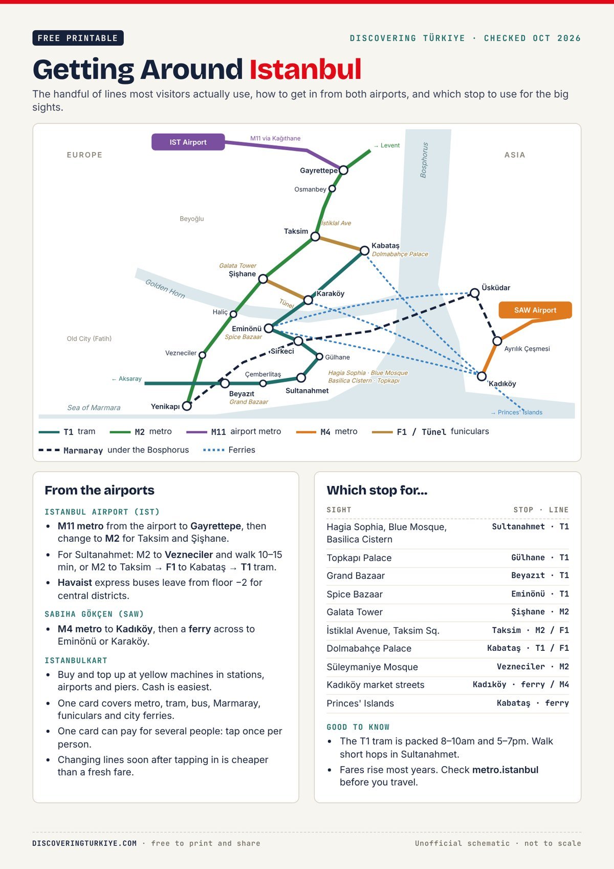
One A4 page covering the network a first-time visitor actually needs, not all 20-plus lines.
Istanbul raises public transport fares most years, and a printable gets passed around for a long time. Rather than print a number that goes stale, the sheet points you to Metro Istanbul for current prices.
Take the M11 metro from Istanbul Airport to Gayrettepe, then change to the M2 for Taksim and Şişhane. For Sultanahmet, stay on the M2 to Vezneciler and walk 10–15 minutes, or ride to Taksim and take the F1 funicular down to Kabataş for the T1 tram. Havaist express buses also leave from floor −2 of the airport. From Sabiha Gökçen, the M4 metro runs to Kadıköy, where ferries cross to Eminönü and Karaköy.
For neighbourhoods, transit cards and when to go, see our Istanbul guide. If you’re still checking paperwork, start with Turkey entry requirements by nationality.
Yes. The cheat sheet is free to print, share and embed, as long as you credit Discovering Türkiye with a link to this page. Copy this code to embed the preview:
<a href="https://discoveringturkiye.com/istanbul-transport-cheat-sheet/"><img src="https://discoveringturkiye.com/wp-content/uploads/2026/10/istanbul-transport-cheat-sheet-preview.jpg" alt="Getting Around Istanbul transport cheat sheet" width="600"></a>
<p>Istanbul transport cheat sheet by <a href="https://discoveringturkiye.com/istanbul-transport-cheat-sheet/">Discovering Türkiye</a></p>
No. It’s an unofficial, simplified schematic of the lines visitors use most, and it isn’t to scale. For the full network, see Metro Istanbul’s official maps.
Yes. The same Istanbulkart works on Istanbul’s city ferries as well as the metro, tram, buses, Marmaray and funiculars.
No. One card can pay for several people travelling together; you tap it once per person. A card each is handier if you’ll split up during the day.

An Istanbul photoshoot is a private session with a local photographer, usually 30 minutes to 2…
Read more →
Every rule for US, UK, Canadian, Australian, German and Dutch travellers, checked against Türkiye's foreign ministry…
Read more →
Süleymaniye Mosque is Mimar Sinan's 1557 Ottoman imperial mosque on a hilltop above the Golden Horn…
Read more →
Comments